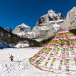
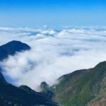
One must go to Ali in one’s lifetime. Tibet is a place that many people yearn to reach. I think many people, like me, have a dream of Tibet. Everyone who goes to Tibet has their own reasons. Some go for faith, some for healing, some for dreams… Perhaps there is no need for any reason to go to Tibet. This magical land endows Tibet with a mysterious color and makes everyone yearn for it. It is said that one’s life is complete only after going to Tibet once. Fortunately, due to work reasons, I have entered Tibet more than ten times in the past two years. I have left my footprints on the Sichuan-Tibet line, Yunnan-Tibet line, and Qinghai-Tibet line, but唯独 have not walked through Ali region, which is also my greatest regret. ‘No Ali, no Tibet’. Many people say that if you haven’t been to Ali, you haven’t been to the real Tibet. So going to Ali has always been on my mind. Perhaps the fate of meeting Ali has arrived. In October last year, I finally set foot on this land with like-minded friends. So, the place where you dream of going will be reached one day. Ali, a place full of mysterious colors. Ali is located at the westernmost end of Tibet, at the highest part of the main body of the Qinghai-Tibet Plateau. The average altitude is above 4,500 meters, and the area is 310,000 square kilometers, accounting for one-fourth of the whole territory of Tibet. It is known as the ‘roof of the roof of the world’ and the ‘third pole of the world’. There are magnificent famous mountain ranges such as the Himalayas, the Gangdise Mountains, the Kunlun Mountains, and the Karakoram Mountains. Numerous snow-capped mountains and glaciers endow Ali with abundant water sources. There are the Shiquan River, the Maquan River, the Xiangquan River, and the Peacock River, which are the sources of the Yarlung Zangbo River, the Indus River, and the Ganges River respectively. The northern part of Ali is the vast Hoh Xil no-man’s land, where many rare wild animals grow. Mount Kailash and Lake Manasarovar are famous sacred mountains and lakes in Tibet, with many pilgrims. They are the most fascinating human and natural landscapes in Ali region. For Tibetan Buddhists, there are thousands of sacred mountains in Tibet, and Mount Kailash is the greatest one. This is also the reason why I have always wanted to come to Ali to take a look at the sacred mountains and lakes. This land of Ali endows too much mysterious color. Rivers with thousands of years of historical memory, magnificent and spectacular soil forests, clear and blue lakes, majestic and holy sacred mountains… All these have become the beliefs in the hearts of Tibetans. I think only when you walk through this land of Ali can you truly understand that Ali is the Tibet within Tibet. Ali region includes seven counties: Gar, Purang, Coqen, Ge’gyai, Gerze, Zanda, and Rutog. Ali region is in the western part of Tibet, but not all areas west of Lhasa or the entire northern Tibet belong to Ali. When we usually say self-driving around Ali, it does not only refer to self-driving in Ali region. Instead, it will include beautiful sceneries such as Yamdrok Lake, Namtso Lake, and Mount Everest that do not belong to Ali region one by one, and connect with the beautiful sceneries of Ali to form a loop west of Lhasa. So Lhasa is the starting point and also the end point.
The Ali Circuit, varying in difficulty, is divided into the South Ali Line, the Great North Ali Line, the Central North Ali Line, and the Small North Ali Line, with different time arrangements depending on the chosen route. For this journey, we opted for the South Ali Line, departing from Lhasa, passing through Yamdrok Lake, Mount Everest, Lake Manasarovar, Mount Kailash, and Zhada’s Earth Forest, reaching the ancient Guge Kingdom before returning to Saga via the same route, adhering to the ‘South In, South Out’ principle. Among the highlights of the trip, the autumnal Yamdrok Lake, with its azure hue, shimmers under the afternoon sun, a sight worth the effort to seek out in the direction of Rituo Monastery. Encountering wild donkeys roaming freely on the journey paints a captivating scene. Lake Manasarovar, resembling a sapphire, with its tranquil waters and azure lake, merges with the distant snow-capped mountains to form an exquisite highland landscape. Upon seeing Zhada’s Earth Forest, one truly understands the meaning of grandeur. The Guge Kingdom, surrounded by layers of varied earth formations, adds an air of mystery to the desolate plateau. Alongside National Highway G219, we encountered an expansive desert, merging with lakes of various sizes, with meadows, rivers, and sand dunes together creating a colorful canvas of the earth. Gazing at Mount Kailash so closely, one realizes the insignificance of oneself in the face of nature. The pilgrimage around Mount Kailash, where ‘the body is in hell and the eyes are in heaven,’ offers a view with every glance that can harbor beautiful wishes. On the way to Mount Everest, the beautiful moments encountered—mountains, lakes, and flocks of sheep—heal the soul. The sunset at Mount Everest, revealing its dazzling radiance in the last light of the sun, is the most beautiful I have ever seen it. Returning to Lhasa always brings unexpected surprises. This time, focusing on the South Ali Line, we chose to fly directly to Lhasa, arriving two days earlier to acclimatize and prepare for the Ali journey. Having visited Lhasa many times, I still unconditionally love this city. Having seen it in all seasons, Lhasa remains forever bathed in the sunlight of the snowy plateau in my memory. One must visit Lhasa at least once, to feel the evening breeze on Beijing Road, stroll through the ancient Barkhor Street, sip a few cups of sweet tea, visit the Jokhang Temple, and experience a place that lacks oxygen but not faith. Barkhor Street, where one can experience the local Tibetan culture and the essence of life. Those who have been to Lhasa are no stranger to the name Barkhor Street. First-time visitors to Lhasa will not miss the opportunity to wander through Barkhor Street. This street, traversing time and space, has witnessed the past and present of Lhasa.


Barkhor Street is located in the ancient city area of Lhasa. It is a famous circumambulation path and commercial center in Lhasa, and it has relatively completely preserved the traditional appearance and living style of the ancient city. The original street of Barkhor Street was only a single circumambulation path around the Jokhang Temple. Tibetans call it the ‘holy road’. Now it has gradually expanded into a large area of old blocks surrounding the Jokhang Temple. Barkhor Street is the best place to feel the sunlight of Lhasa. The sky is clear and blue, and the clouds seem within reach. Buildings of Tibetan style and various healing colors unfold before our eyes, forming a unique landscape here. As night falls and the lights are first lit, strolling on the street, the orange street lights are warm and charming. Against the deep blue sky, there is a warmer feeling. Compared with Barkhor Street during the day, it is more mysterious and unique at night. Under the night, Barkhor Street hides the countless fireworks of the ancient city of Lhasa. Strolling here, time seems to stand still, and the whole person becomes quiet and relaxed. The taste of a city is all in time. When you come to Barkhor Street, even if you don’t buy anything and just stroll casually in the crowd, or find a sweet tea house and sit quietly looking at the people coming and going outside. In the tide of circumambulation, you can still find that familiar taste, find the time that belongs to you and Lhasa, and still be inexplicably moved by some small details. Every city has a magnificent side and another side full of human fireworks. Lhasa is no exception. [????????]? Address: Barkhor Street is located in the center of Lhasa, next to the Jokhang Temple. There are buses available, and taking a taxi in the urban area is also convenient. Remember to bring your ID card. You need to swipe your ID card for security check to enter. There are many internet-famous stores on Barkhor Street, such as Makye Ame, Adiao Milk Tea, Magpie Pavilion Sweet Tea House, etc. You can experience them all. Sweet tea is recommended. As for Tibetan cuisine, it depends on personal taste. I really can’t get used to it. There are also many travel photography studios on Barkhor Street that provide Tibetan costume photo shoots. The price is not expensive. Friends who want to leave beautiful memories for their travels can also experience it. Barkhor Street is a circular block. It is recommended that when everyone plays, take the Jokhang Temple as the starting point and turn clockwise. There are many photo spots on Barkhor Street. The main street, in front of shops, and every alley are all microcosms of local people’s daily lives (photography is prohibited inside temples). Potala Palace, feel its magnificence from multiple angles. Whether people who have been to or have not set foot in Tibet, there is always an indescribable complex for Tibet, and they are especially fond of the thousand-year-old Potala Palace. So when you come to Lhasa, you must definitely go and see the Potala Palace. The Potala Palace is the grandest building integrating palaces, castles and monasteries at the highest altitude in the world. It is also the largest and most complete ancient palace complex in Tibet.
The Potala Palace, with its terraces stacked against the mountain and overlapping pavilions, stands majestically as an outstanding representative of Tibetan ancient architecture. It also graces the back of the 50-yuan note of the fifth series of the Renminbi. The main structure is divided into the White Palace and the Red Palace, with the palace towering over 200 meters high, appearing as a 13-story building from the outside but actually consisting of 9 levels inside. The architectural style of the Potala Palace is predominantly white and red, with distinct colors. Standing in the Potala Palace Square, one can feel the grandeur of this building against the backdrop of blue sky and white clouds. After witnessing the palace during the day, do not miss its appearance at night. Watching the sunset and the lights coming on, the Potala Palace under the starry sky takes on an air of mystery. Observing each brick and tile, each blade of grass and tree, with fewer crowds, gazing at the Potala Palace in front of you feels like stepping into a distant dream. Having seen the Potala Palace many times and captured it from various angles, here are some recommended spots for photographing the palace from different perspectives:
– Potala Palace Square: Directly opposite the Potala Palace, this is a must-visit place for everyone in Lhasa to see the palace and the best spot to capture its full view. Using a telephoto lens here can yield excellent close-ups of the palace or portraits. To capture reflections, you can pour water on the ground or use your phone screen to reflect the palace’s image.
– Remember to carry your ID card as security checks and ID scans are required to enter the square.
– The Medicine King Hill Observation Deck, located diagonally across from the Potala Palace, is also the vantage point for the 50-yuan Renminbi note. Although the space is small, it is often crowded, and there are often queues, so it’s advisable to manage your time well.
– The lakeside next to the Potala Palace Square: It takes less than two minutes to walk there from the palace square. The lake, surrounded by greenery, reflects the image of the palace, creating a particularly artistic scene. The view is transformed into another beautiful scene as the sun sets.
– The overpass at Barkhor Shopping Mall: The bustling image of the Potala Palace seen online is captured from this location. This spot is indeed very popular, always filled with people, so it’s recommended to go early.
– Be sure to bring a telephoto lens here, or you won’t achieve the desired effect.
– The location can be found by searching for ‘Barkhor Times Square’ on the overpass at the intersection of Lin Guo East Road and Beijing East Road.
– Nanshan Park: By the lake, you can photograph the reflection of the Potala Palace, but it’s best when the lake water is calm. When I visited, there was wind, so the reflection wasn’t very clear.
– The mid-hill observation deck offers a view of the Potala Palace surrounded by the entire city of Lhasa.
– This location is a bit far from the urban area of Lhasa, with no bus service available at the moment. It costs about 30 yuan to take a taxi from the Potala Palace, or you can drive or cycle there.
– Cilandu·Coffee Cafe: Located on the 6th floor of the Cilandu Hotel in the Barkhor Street business district, you can directly reach it by elevator from the ground floor.
From the balcony of the café, you can clearly see the Potala Palace standing majestically ahead. Sipping a cup of coffee here, gazing at the Potala Palace before you, isn’t that particularly delightful? Address: 6th Floor, Cidu Hotel, No. 34 Lin Guo South Road. Make an appointment for the ticket one day in advance on the official WeChat account ‘Potala Palace Official Platform’. After successfully making an appointment, enter with your ID card and electronic code from the south gate. Sometimes there is a long queue for security checks, so it’s advisable to arrive a bit earlier. At the ticket office halfway up the mountain, purchase your ticket with your ID card. Photography is prohibited inside the palace, hats are not allowed, and skirts are not permitted; otherwise, entry will be denied. There is an uphill staircase leading to the palace, so it is recommended to wear flat shoes or sports shoes, as climbing slopes at high altitudes can be very tiring. At the entrance, there are guided tours for 50 yuan per person, usually forming small groups of several people. Those who wish to learn about the history of the Potala Palace should follow the guide closely. Yarlung Zangbo, the enchanting highland blue—what shade of blue is sufficient to match the captivating lakeside of Yarlung Zangbo? Forget how many times I’ve visited Yarlung Zangbo; it’s always been a lingering obsession in my heart, willing to go through hours of trouble to seek out the Yarlung Zangbo in the direction of Rituo Monastery. Perhaps it’s the favor of the heavens that I’ve encountered its most beautiful form. Yarlung Zangbo, also known as Yangzhu Yumco, is one of the three sacred lakes of Tibet. The lake has an elevation of 4441 meters and is the largest inland lake on the northern slopes of the Himalayas. The beauty of its lake and mountain scenery is unparalleled in southern Tibet. The color of Yangzhu Yumco’s water is influenced by the weather; under different sunlight, the lake water changes with the movement of the sun’s rays, presenting various shades of blue, sometimes deep and sometimes shallow, evolving into a myriad of blues. When visiting in the autumn, Yarlung Zangbo hidden in the valley appears in a azure hue. In the afternoon, sunlight sprinkles on the lake surface, sparkling like starlight. Circumnavigating the lake in the thin air of the highlands, one is deeply healed by the blue before their eyes. The blue here is particularly pure, making one unable to help but become still. Even though the journey is long, seeing such beautiful scenery makes you feel that all the hardship along the way is worth it. You can never get enough of the blue sky, white clouds, and lakes here. On clear days, the sky here paints, and the calm lake reflects the blue sky and white clouds, just like a beautiful scroll laid out before me, making it impossible to distinguish between the water and the sky. On this lake island, there stands a solitary temple, known as Rituo Monastery. Rituo Monastery, meaning ‘stone on the mountain,’ is the only building on this peninsula. One lake, one temple, one monk, one life—this is how 700 springs and autumns have passed. This place is the best viewing platform for Yangzhu Yumco. Standing on the mountain top, one can enjoy a 360-degree view of the color changes of Yangzhu Yumco. On this land, you will encounter the highland blue again and again.
This gentle blue makes people forget themselves. Sitting by the lake, watching the clouds roll and relax. The dazzling sunlight, pure lake water, the sound of wind and birds passing by the ears. Let the thoughts float and enjoy this tranquility and loneliness. [????????]? I have seen Yamdrok Lake many times. Previously, what I saw were the spots where ordinary tourists usually take pictures. The familiar roadside viewing platforms. This is the first time heading in the direction of Riwoche Monastery. At the moment I see it, I admit that this is the most beautiful sight I have ever seen. Starting from Lhasa and taking the Yamdrok Lake loop, you can reach it by navigating to ‘Riwoche Monastery’. Along the way, there will be mountainous winding roads. When approaching Riwoche Monastery, there is a section of unpaved road with many pits and gravel. Drive slowly. The scenery along the way around the lake is extremely beautiful. The lake water is clear and blue. On the way, you may occasionally encounter lovely creatures on the plateau. The grass and mountains by the roadside are all worth seeing. Here, not only is it quiet with few people, but you can also see a bluer lake. Looking down at this azure lake from the top of the mountain, the pure blue is so beautiful that it seems a bit unreal. The sunlight shines on the lake surface, just like a dream. Ticket: 20 yuan per person.普兰县, an unexpected surprise on the way to Ali. Purang County is located in Ali Prefecture, Tibet. In the canyon area on the south side of the Himalayas, at the junction of China, India and Nepal. It is an important border defense area and also a county surrounded by snow-capped mountains. You can see snow-capped mountains as soon as you go out. We didn’t originally plan to stay here. But due to some accidents on the road, we had to stay here for one night. This also gave us time to get to know this county. Purang County precipitates the collision of cultures of three countries. I fell in love with this small town at first sight. When you come to Purang, the China Tibet Purang border trade market is recommended for you to take a look. There are many stores opened by Nepalis and Indians. The stores are filled with all kinds of exquisite handmade wood carvings, prayer beads, brown sugar, coffee, etc. There are everything from daily necessities to clothing to food. The variety of goods is dazzling. In addition to the stores, there are also Nepalese restaurants. While strolling here, you can also experience the local life and characteristic cuisine. In Purang County, there is an inconspicuous path. Driving along the winding upward road to the top of the mountain, there is an ancient city ruin and the ruins of Xiangbailin Monastery. Surrounded by snow-capped mountains, standing on the top and looking out is the Himalayas. In the desolate ruins, only the incomplete earthen walls stand on the top of the mountain. Despite the wind and rain, and the ravages of time and the erosion of wind and sand, they still hold on to their former glory. From these ruins, one can vaguely see the grandeur of the past. Except for us, there are no other tourists here. It is very quiet. Only the howling wind echoes in the ears. Next to the ruins of Xiangbailin Monastery, a monastery has been built. Although the scale of the building is not large, the solemn momentum of the monastery still exists.
Standing on the plank walkway, one’s view is expansive, capturing the entirety of the Purang River Valley, with the surrounding Himalayan Mountains undulating in majestic grandeur. The ancient and modern cities blend seamlessly, with the mists of history settling here. In Purang County, another place I highly recommend is Kejia Monastery, located less than 20 kilometers from the county town. Kejia Monastery is a Sakya sect Buddhist temple and the most important temple in the southern part of the Ngari region, with a history of over 1000 years. It is situated atop Kejia Village, with another nation—Nepal—beyond the mountains. Encircled by snow-capped mountains to the north and south, with the Gangdise Mountains as a barrier to the north and the Himalayas as the boundary to the south, it is truly a ‘temple embraced by snow mountains’. Despite its infrequent visitors, Kejia Monastery is not lacking in beauty; the red walls contrast with the blue sky, exuding an antique yet solemn aura. Outside the temple, the scene is different, compelling one to linger. The prayer wheels outside the temple add to its solemnity under the sunlight, where faith is omnipresent. [????????]? Surrounding Purang County are attractions such as Lake Manasarovar, Lake Rakshastal, and Mount Kailash. If not climbing Mount Kailash, one can choose Purang, which is at a relatively lower altitude, as a transit point. The county’s infrastructure is now well-developed, with hotels, restaurants, and shops available, so there’s no need to worry about accommodation and meals. The local restaurants primarily serve Indian, Nepalese, and Tibetan cuisine. The border trade market features sweet tea houses and shops with distinctive Nepalese and Tibetan styles. Due to the pandemic, there are fewer people, and some shops are not open. Lake Manasarovar, a ‘sapphire’ on the plateau, among the countless lakes of various sizes on this vast plateau, especially along the Ali line, one might experience visual fatigue from the numerous lakes, but the most famous are still the three sacred lakes worth ‘lake upon lake’: Yamdrok Lake, Namtso Lake, and Lake Manasarovar. Yamdrok Lake and Namtso Lake are closer to Lhasa, making them relatively easier to reach, while Lake Manasarovar, as the foremost of the three sacred lakes, is less visited due to its distance. Having seen Yamdrok Lake and Namtso Lake many times, seeing Lake Manasarovar has always been on my travel bucket list, so I unhesitatingly included it in my Ali trip. Lake Manasarovar is located in Purang County, Ali region, about 20 kilometers from Mount Kailash, between the main peak of the Gangdise Mountains, Mount Kailash, and the Himalayan peak, Mount Nalakan. Its surrounding natural scenery is very beautiful, and Buddhist believers have long regarded it as a sacred ‘center of the world’. In Tibetan, Lake Manasarovar means ‘the eternally undefeated jade lake’.
The lake water originates from the melting snow and ice of the Gangdise Mountains, making it the fresh water lake with the best water quality and highest transparency in China. It is also the most representative lake wetland on the plateau. Around Lake Manasarovar, you can find the sacred Mount Kailash, the ‘Goddess Peak’ Namtso Nani, and the ‘Ghost Lake’ Rakshas Tal. This area, known as the ‘Sacred Mountains and Holy Lakes,’ is a place longed for by many travelers. Upon my first visit, the tranquil lake surface, the blue-green lake water, and the gentle breeze made me forget about time, and my restless heart was also calmed. The blue of Lake Manasarovar is slightly different from the blues I have seen in other lakes; it is like a huge sapphire laid out before me, deeper in color. Under the sunlight, the dark blue lake surface sparkles with tiny glints of light. The lake, snow-capped mountains, and blue sky blend into one, making one feel as if they are in a fairyland. From the top of the hill overlooking Lake Manasarovar, snow-capped mountains, lake water, prayer flags, and pagodas unfold before your eyes. It is undeniable that Lake Manasarovar is beautiful. The lake shore stretches into the distance, with Namtso Nani Peak in the background. This lake water is probably tempered by a thousand years of ice, shining with the crystalline radiance of cold jade and a hint of cool air. Standing on top and looking at all of this, birds flying over the lake surface, changing clouds, and the shimmering light and shadow, it feels as if the whole world has sunk into a dream. [?????]? Admission: There is a ticket office at Lake Manasarovar, charging 150 yuan per person, but it is not necessary to buy a ticket. Drive a few dozen kilometers towards Pulan County, and there is a free viewing platform (which is where we went). You can also drive your car to the lake side, but be careful of the narrow road and many small stones. Some paths by the lake are like the picture shown? You can drive your car directly to the lake, get close to Lake Manasarovar, watch the migratory birds fly, and see the glittering lake surface… The scene is very aesthetically pleasing. It is also possible to take some wide-angle shots and close-ups of people, which are very photogenic.? Driving along the path to the top of the hill, overlooking Lake Manasarovar from the top, the view becomes even broader. The distant snow-capped mountains and lakes form a breathtakingly beautiful highland landscape painting. Circumambulating Mount Kailash, everything is the best arrangement. Mount Kailash is the most anticipated stop on this Ali trip. It is the foremost of the sacred mountains and is considered the center of the world. Mount Kailash, along with Mount Meili in Yunnan, the Amne Machin range in Qinghai, and the Garze Gyebong Karchung in Qinghai, are known as the four sacred mountains in Tibetan Buddhism. The Gangdise Mountains stretch between the Kunlun Mountains in the north and the Himalayas in the south, like a giant dragon lying on the vast plateau of Ali. Its raised head, like a pyramid, stands on the plateau of Ali Purang, which is the main peak of Mount Kailash. Mount Kailash is 6,656 meters above sea level and is known as the King of the Sacred Mountains. It is recognized as the center of the world by Hinduism, Tibetan Buddhism, Bon religion, and ancient Jainism.
It is a sacred land for pilgrims, a paradise for explorers, and a dream destination for many travelers. Every year, countless believers from around the world come to circumambulate Mount Kailash, and numerous travelers come to experience the pilgrimage journey. Many might ask, what is circumambulation? Circumambulation refers to the ritual of repeatedly walking around a spiritual mountain, which is the most devout way to worship the sacred mountain. Tibetans believe that those who suffer can attain purification of sins and purity of the body and mind through this practice. Circumambulators must abandon personal desires and walk solely to pray for the well-being of others. It is said that for pilgrims who come here to circumambulate once, they can wash away the sins of a lifetime; ten circumambulations can spare one from the sufferings of hell for five hundred reincarnations; and a hundred circumambulations can lead to enlightenment and ascension in this life. For believers, circumambulation is a form of spiritual practice, and their greatest wish in life is to go to Mount Kailash for circumambulation, for which they prostrate and kneel all the way to the sacred mountain. For ordinary people, circumambulation may represent a completion of the self, a spiritual journey of the heart. Walking on the plateau at an altitude of 5,000 meters, covering more than 50 kilometers of circumambulation path, through wind, frost, rain, and snow, it is a test of spirit, physical strength, willpower, and endurance, as well as a journey of the soul and a feast for the eyes. After experiencing circumambulation, everything here will tell you the power of faith. After talking about circumambulating Mount Kailash for a long time, I finally did it this time. Now, recalling that day’s journey, those scenes vividly emerge in my mind. The three of us planned to spend two days on the circumambulation. We set out from Tarqin before dawn, hiking to the prayer flag square with the local Tibetans, which is about 7km from the scenic area reception center (one could choose to take a vehicle here). On this land of the plateau, every moment can bring unexpected surprises. As we moved forward, with the dawn breaking, we encountered the snow-capped mountains in the morning light, watching the pink dawn spread across the sky, spilling over the horizon. It must be the charm of the dawn, even the cold of the plateau’s early morning has become warm. When we went, it was already October, and there were not many people circumambulating, mostly Tibetans, occasionally encountering a few tourists like us. After reaching the prayer flag square and hiking another 2km, we arrived at Chugu Monastery, which is considered the true entrance for circumambulation. Here, one can clearly see the peak of the sacred mountain, and at that moment, the heart is filled with excitement. We started walking together, but later Sister Mei walked faster, and my other friend Bao and I fell behind. At that time, we thought that there was only one path, and we would catch up later. Perhaps the heavens wanted to test us, starting from Chugu Monastery, Bao and I took the wrong path (at that time, seeing Sister Mei in front, we thought about catching up with her), a small river divided us.
As we continued forward, we found ourselves at a standstill, nearly collapsing. It was then that we decided to turn back, starting anew. At that time, we had already trekked 12 kilometers. When we set out again from the Qugu Monastery rest station, it was already 3 in the afternoon. Thus, on the first day, we opted to stay at Zhe Ri Monastery, while Mei Jie had already reached the next rest station. The pilgrimage path that was meant to be walked together by three had thus separated. When we arrived at the nearby Shen Shan Inn around 7 in the evening (having trekked 32 kilometers that day), gazing at the seemingly close Kangrinboqe, it felt within arm’s reach, never had I imagined getting so close to it. At that moment, I couldn’t help but shed tears, unable to articulate why – excitement, joy, hardship… With another 32 kilometers to go, we set off at 6 the next morning, fortunately accompanied by local Tibetans along the way. The journey was fraught with strong winds, cold, icy roads, and falls, and trekking on the plateau was never easy. When we reached the endpoint, it was already past 9 in the evening. These two days of pilgrimage were truly accomplished by sheer willpower. Honestly, the two days of pilgrimage were ten times more arduous than I had imagined, and now when I recall, I don’t know how I managed to persevere. Once踏上 this path, there’s no turning back, with only the unending horizon ahead. Along the way, we encountered many Tibetans prostrating themselves, crossing mountains and waters, regardless of wind and rain, regardless of the future. When we saw the pilgrims raise their hands above their heads, bend their bodies, and prostrate themselves with a single-minded devotion, those pious silhouettes moved me deeply, etching themselves into my heart. Suddenly, on this tranquil land, the power of faith felt incredibly strong. Climbing over the 5648-meter Zhuoma La pass, hanging prayer flags, watching the sunrise illuminate the sacred mountains, gazing at the myriad stars… Suddenly, I felt this was a very romantic thing. When we reached the endpoint, all the falls, foot pain, and shortness of breath along the way were worth it. I am grateful to the Tibetan elder who gave us flashlights, the Tibetan mother and sisters who invited us to drink sweet tea and eat along the way, the Tibetan brother who helped us down the slope, and every kind smile… Although the weather was very cold, the journey was filled with warmth and love. There are no steps in life that are in vain, every step counts. I am thankful for the trials and blessings from above; this must be the most unforgettable and precious experience of my life. The pilgrimage path, where ‘the body is in hell, and the eyes are in heaven,’ every view can hold beautiful wishes, and every pilgrim can bring us strength and courage.
Recalling a line from the film ‘Kangrinboqe’: ‘There is no completely correct way of life in this world. The sacred mountains and holy lakes are not the focus. Accepting the ordinary self, yet not giving up on ideals and beliefs, loving life, we are all on the way.’ [?]? Circumambulation date: October 12/13, 2021. The circumambulation of Mount Kangrinboqe is divided into inner and outer routes; we took the outer route. Inner route: It is said that devout believers must complete 13 outer circumambulations before they can embark on this route, which is generally not chosen by ordinary tourists. Outer route: Starting from Tarqin, we circled around the sacred Mount Kangrinboqe and returned to the starting point, covering approximately 52 kilometers, which usually takes two days to complete.? The weather in October generally ranges from below freezing to around 10 degrees Celsius; it can be colder in the mountains, with an average altitude of over 4900 meters and especially strong winds.? Essential items to bring: trekking poles (most hotels can lend them), waterproof jackets, hats, gloves, and other warm clothing, non-slip and comfortable shoes, as well as sun protection items such as sunglasses, sunscreen, and face masks due to the strong ultraviolet rays.? Along the way, there are supply points every few kilometers where you can purchase sweet tea, water, oxygen, and instant noodles. It’s best to travel light and carry minimal items, but you can prepare some glucose and chocolate to replenish energy.? It’s advisable to bring some cash, as sometimes there is poor mobile signal and online payments are not possible.? If you choose to circumambulate in two days, you can opt to stay at Zhe Ri Temple. We stayed at the Sacred Mountain Inn opposite Zhe Ri Temple, facing the sacred Mount Kangrinboqe, at 60 yuan per bed. You can enjoy the sunrise on the golden mountain or photograph the starry sky, which is incredibly beautiful. If you cross the pass on the first day, you can choose to stay at Dongbu Di Ding, at 100 yuan per bed.? We set off at 6:30 am the next morning, and after crossing the 5648-meter altitude of the Dolma La pass, we thought we were close to the end, but the next 20-plus kilometers truly tested our perseverance. Fortunately, we were lucky to complete the entire journey.? If you plan to circumambulate Mount Kangrinboqe, you generally first arrive at Tarqin, then depart from Tarqin to the sacred mountain reception center to purchase tickets. From here, you can choose to travel by car or on foot to the prayer flag square (about 7km) in Zhada County, a masterpiece of nature located within Zhada County, Ali Region, Tibet, China, and is the most famous geomorphological scenic area in Zhada County. Across the vast land of China, there are various natural wonders such as stone forests and earth forests, but in terms of grandeur and imposing presence, Zhada Earth Forest is undoubtedly the most spectacular. Only after seeing Zhada Earth Forest can one truly understand what grandeur means. We set off from Purang towards the ancient Guge Kingdom, heading deep into Ali along National Highway G219. After more than five hours of driving, Zhada Earth Forest began to appear in our view, and we were truly shocked by our first sight of it.
Hundreds of kilometers of continuous earth forests unfold before our eyes, just like an alien planet. It is extremely spectacular. Seeing the landscape in front of us, we couldn’t wait to find an observation deck by the roadside. Standing at a high place and overlooking this magnificent earth forest, looking at the layers of gullies stretching into the distance and connecting with the snow-capped mountains, we can’t help but sigh at the elaborate carving of nature. It is said that more than a million years ago, there was a large lake with a radius of more than 500 kilometers between Zanda and Purang. The Himalayan orogeny caused the lake basin to rise and the water level to decrease. After hundreds of thousands of years of erosion by wind and rain, this wonderland emerged. Looking at this earth forest in front of us, we can freely exert our infinite imagination and see various shapes, like magnificent and towering pagodas, luxurious palaces, and warriors holding spears… The earth forests with different heights and postures are set off by the psychedelic light and shadow on the plateau. The Zanda earth forest is like a mysterious alien world, making people can’t help but sigh at the uncanny creativity of nature. As the car travels through the earth forest, one after another earth mound is as dense as a forest sea and appears before our eyes. Only by being on the scene can we feel the majesty and grandeur of the earth forest. Regrettably, because our previous schedule was delayed for some time, we didn’t reserve more time for shooting in the earth forest. But the magnificence of this earth forest has been deeply engraved in our hearts, and we also silently make a wish, ‘We must come here again.’ [????????] At present, the Zanda earth forest does not need to charge. There are sceneries everywhere on the road. You can slowly find shooting positions. There are also temporary observation decks for taking pictures. The roads among the earth forests are all cement asphalt roads. Cars can drive among them. At every turn, there is a shocking landscape. If you want to take portraits or close-ups, it is recommended to use a telephoto lens, so that it is closer to the scene. If you want to take a relatively complete view, you can use a wide-angle lens. After we passed through the Zanda earth forest, we unexpectedly found a small lake. It is a very beautiful emerald green. Surrounded by the earth forest, it has a very sharp contrast with this vast and magnificent land. It is like the tenderness carefully hidden by this land. [????????] This is not a scenic spot, so not many people know about it. We are walking from the Zanda earth forest towards the ancient Guge Kingdom. Not far from the county town, there is a small path on the left. Next to it is a small stream. Walking inside for about 10 minutes, you can see it. The roadside here is very wide and you can park. Just park a little closer to the side. Taking pictures from a high position with a drone can better highlight its beauty. The ancient Guge Kingdom, the mysterious castle on the Ali Plateau. In Zanda County, Ali District, Tibet, there is a mysterious ruins of the ancient Guge Kingdom. This is also one of our initial motivations for going to Ali this time. The entire castle of the ancient Guge Kingdom is built on a loess slope more than 300 meters high on the banks of the Xiangquan River. It is surrounded by earth forests with different layers and shapes. There are steep cliffs on all sides, and the situation is extremely dangerous.
Caves, stupas, watchtowers, temples are arranged in an orderly manner from bottom to top, presenting a magnificent and spectacular sight. After the vicissitudes of time, the relatively well-preserved ones up to now are the Red Temple, the White Temple, and some palaces. There is a Mandala Hall on the top of the mountain, but it is not open to the public. There are also some exquisite murals and sculptures. Although the murals are of an ancient age, their colors are still very vivid. When we went there, the Red Temple was not open, which is a bit of a pity. Looking at this ruin in front of us, it is hard to imagine that on this vast land, there once existed the ancient Guge Dynasty with a glorious history and civilization lasting for 700 years. Before the 20th century, no one knew the existence of this mysterious dynasty ruins. Its architecture, history, civilization, religion, murals, and art were all unknown. The biggest mystery of the Guge Dynasty is how 100,000 people disappeared without a trace overnight. This is unbelievable and cannot be explained. The source of the history of the Guge Kingdom can be traced back to the late Tubo Dynasty. The Guge Kingdom developed production internally and fought with neighboring countries, all of which required manpower and financial resources. However, with the expansion of the power of Tibetan Buddhism, the contradiction between the king and the Buddhist leader became increasingly acute, leading to war and ultimately its demise. Although there are many theories about its disappearance, in fact, it is probably due to war. Although the Guge Dynasty may not seem very high, reaching the top is not an easy thing. Especially in this high-altitude area, climbing is already a difficult task. I remember that although there were not many people that day, what moved me was that people going back and forth would cheer each other on all the way and encourage everyone to climb to the top. When we arrived, there was a strong wind blowing. The sand and dust were blown on us along with the strong wind. In order to reach the top, we walked up against the wind and sand. When we came down from the top, our faces and clothes were covered with dust. This may be one of our most ‘miserable’ trips. Ascending the steps on the silent and deserted ruins, the ancient Guge Dynasty, an ancient castle permeating with a sense of incomplete and tragic beauty, stands quietly there, as if telling the past sorrows to the world. Suddenly, it seems that those unrests that have lasted for thousands of years have never happened on this land. Panting all the way and climbing to the topmost part of the ruins, the view from the top is very wide. Looking out at this vast land, around the Guge Dynasty are magnificent and continuous earth forests. Some are like lined-up soldiers, as if waiting for inspection. Some are like city walls, as if guarding this majestic castle… All of this is astonishingly spectacular. The unique and magnificent architecture, exquisite murals, and mysterious history of the Guge Dynasty attract many people to come here out of admiration. But regarding its tragic and vicissitudes-filled history, one can only search for it from the broken soil or ruins underfoot.
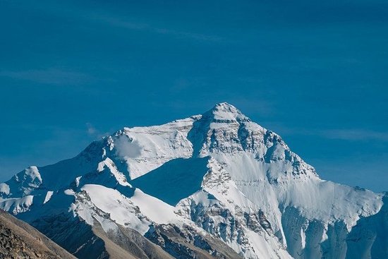
Admission to the ancient Guge Kingdom is 65 yuan per person (cash only). To fully appreciate the ancient city, one must climb from the base to the summit, which can be slightly breathless; avoid rushing, as this is a high-altitude region. There is only one path leading up, thus necessitating a return via the same route. Along the way, you’ll encounter various archways and stairs of varying heights, making it easy to capture both portraits and landscapes. The summit offers excellent photographic opportunities, including a panoramic view of the earth forest and stunning sunset hues (unfortunately, we missed it). For attire, it’s recommended to wear bright colors, as they contrast well with the earthy tones of the surroundings. Mount Everest, Encountering the Highlight Moment at Sunset: Mount Everest, a name I’ve heard since childhood and longed to visit, is the main peak of the Himalayas and the highest mountain in the world, located on the border between China and Nepal. In Tibetan, ‘Jo-mo’ means ‘goddess’ and ‘Lang-ma’ means ‘mother elephant,’ symbolizing ‘Mother Earth.’ Many hikers consider climbing Mount Everest their ultimate dream. We departed from Saga at around 9 a.m. and arrived at the Mount Everest National Park in the afternoon. After purchasing tickets, we proceeded directly to the Everest Base Camp. To reach the base camp, we had to cross the Jiaola Mountain, with an altitude of over 5200 meters, which is the best viewing platform for Mount Everest. Here, besides Mount Everest, one can also see four other peaks over 8000 meters (Makalu, Lhotse, Cho Oyu, and Shishapangma), creating a spectacular view on a clear day. Standing on the Jiaola Mountain viewing platform, one can clearly see the entirety of the 108 turns of Mount Everest, known as the ‘Avenue of the World’s Summit,’ which is thrilling and tests the driving skills of every traveler. Having experienced the thrilling 72 turns of the Nu River on the Sichuan-Tibet Highway, I found the 108 turns of Mount Everest even more exhilarating, causing some companions to feel dizzy and nauseous from the turns. We planned to stay overnight at the Everest Base Camp, so after a brief stop, we continued towards the base camp. Arriving at the final stop of Mount Everest (a few hundred meters forward from the Rongbuk Monastery), one can clearly see Mount Everest without having to walk far. There stands the 8848.86-meter monument of Mount Everest, a must-visit spot for tourists to take a commemorative photo. Once feeling Mount Everest was unattainable, I was already in disbelief when gazing at it from Jiaola Mountain. Upon reaching the Everest Base Camp, Mount Everest was within arm’s reach, the highest peak in the world that I had always longed to see, now truly and vividly before my eyes.
It is truly a privilege to stand at the foot of Mount Everest, gazing upon her sacred face and the pristine snow-capped mountains. The beauty of Everest is unparalleled. The golden hour at Everest is the most dazzling moment, as sunlight gradually washes down from the summit, turning the entire mountain into a radiant golden hue. As the sunset’s afterglow slowly fades, the snowy mountain world becomes more real, a breathtaking scene that astonishes many. The precious golden hour is the beginning of good fortune… As soon as the sky darkens, stars fill the entire night sky, generously bestowing upon us a romantic milky way. When surrounded by the vast starry sky at the foot of the world’s highest peak, no amount of words can describe the feeling at that moment. It truly embodies the phrase ‘romance until death do us part’. Only by witnessing it can one understand why Everest is dubbed ‘a place worth visiting at least once in a lifetime’. The entrance fee: On the first day of the ‘Winter Tour of Tibet’ policy, the entrance fee is waived, the round-trip environmental protection vehicle costs 120 yuan per person, and the previously charged 320 yuan for private vehicles is now half price at 160 yuan. Approximately one hour’s drive after entering the national park, you reach the Jiaola Mountain Pass. From the viewing platform, not only can you see the 108 hairpin bends of the mountain road, but more importantly, you can see Mount Everest and four other snow-capped mountains over 8000 meters in the Himalayas, which is extremely spectacular. From Jiaola Mountain Pass, it’s about another hour’s drive to Quzong Village. Private vehicles can only go as far as the parking lot here, then you need to switch to the scenic area’s environmental protection vehicle to reach the Everest Base Camp. Currently, visitors can only reach the campsite at the ‘Mount Everest Altitude Measurement Monument’. If you want to get a close-up view of the Everest starry sky, you can stay at the tent camp next to the Rongbu Monastery, but the accommodation conditions are relatively poor (we were 80 yuan per person at the time). For meals, there is a buffet hot pot across from the Rongbu Monastery, costing 78 yuan per person. The last environmental protection vehicle leaves at 21:30 in the evening. If you do not choose to stay on the mountain, you can arrange your descent time according to your needs. The Everest National Park is at a high altitude, so those prone to altitude sickness can prepare some glucose, painkillers, and oxygen bottles in advance for emergencies. Be sure to wear warm clothes, especially as the wind is strong at night, and even more so if you plan to get up late at night to watch the stars. We were fortunate to have clear skies all the way, witnessing Everest at different times of the day, capturing the golden hour and the romantic starry sky. This Everest trip was complete. Everest is truly beautiful, and I hope that those who aspire to visit Everest will also be able to reach it one day. Ali, the healing moments on the road during a self-driving trip on the Ali road, where the scenery is everywhere along the way, snow-capped mountains, grasslands, lakes, deserts, and freely running wild animals, all display the divine strokes of nature.
Even if the mountains are high and the roads are long, it is still worth making a long journey day and night to embrace this scorching land. On the way to Lake Manasarovar, the weather is surprisingly good. We encounter a small lake that blends with the blue sky, white clouds, snow-capped mountains, and desert. In the magical light of nature, the clouds in various shapes seem within reach, just like a dream. Lake La’ang Co adjacent to Lake Manasarovar is like a huge sapphire scattered on this land. The thoroughly blue lake water is an intoxicating plateau blue. Standing by the lake and looking at Mount Kailash opposite in the distance, it is mysterious and spectacular. On the way to the Guge Kingdom, the sunlight is like a gift sprinkled on the plateau. All living things are frolicking in the sunlight. This vast place is full of wilderness. The two sides of the highway seem to have entered the world of wild animals, all of which are lovely animals. Is there a desert on the Tibetan Plateau? Yes, this is the magical land where snow-capped mountains, sand dunes, meadows, and rivers coexist. Next to National Highway G219, we encounter a vast desert. There is a sand dune on one side and a lake on the other. Sand and water coexist. The desert blends with large and small lakes, appearing soft and dreamy. Meadows, rivers, and sand dunes together form a colorful picture of the earth. The distant snow-capped mountains and continuous deserts are watching each other. Suddenly, we gain a plateau romance from the vast heaven and earth. On the way from Saga to Mount Everest, we encounter Lake Pêkütso. The deep blue lake water, together with high mountains and flocks of sheep, forms a spectacular plateau landscape painting. Having seen thousands of kinds of scenery on the plateau, even if we see it again and again, we are moved every time and full of curiosity every time. Travel guide part Regarding itinerary Day 1: Lhasa – Yamdrok Lake – Shigatse Day 2: Shigatse – Lhatse – Saga Day 3: Saga – Lake Manasarovar – Darchen Day 4: Darchen – Purang County Day 5: Purang County – Zanda Clay Forest – Guge Kingdom – Darchen (This day’s itinerary is a bit rushed. If you have enough time, it is recommended to stay for one more day.) Day 6/7: Two days of circumambulation around Mount Kailash Day 8: Darchen – Saga Day 9: Saga – Mount Everest Day 10: Mount Everest – Shigatse Day 11: Shigatse – Lhasa Regarding transportation The most common means of transportation to reach Lhasa Airplane: Lhasa Gonggar Airport. There is a civil aviation bus directly leading to Lhasa city center at the airport. You can also share a ride or book an online car-hailing in advance according to your own situation. Railway station: Now Lhasa has Lhasa-Linzhi Railway and Qinghai-Tibet Railway. Currently, cities directly connected to Lhasa include Beijing, Chengdu, Xining, Guangzhou, and Lanzhou. Self-driving to Tibet: If you have enough time, you can take routes such as Sichuan-Tibet Line, Yunnan-Tibet Line, and Qinghai-Tibet Line to enter Tibet. Transportation for traveling in Ali Self-driving/chartered car/ride-sharing is the most common way of traveling in Tibet. Generally, those who travel on the Ali Ring Road will first arrive in Lhasa and then set off.
If you prefer not to drive yourself and tire, renting a car with a few friends is the best choice. For one or two people, carpooling is an option. The road to Ali is filled with scenery, allowing you to travel and play at the same time, enjoying the journey to the fullest.
Self-driving: Relatively the most freedom, stopping whenever you want, experiencing the pleasure of driving. However, due to unfamiliarity with road conditions, there may be certain safety risks, and long-distance driving can be tiring. It is recommended to prepare a plan before departure.
Renting a car: Family trips or traveling with friends can choose to rent a car, and you can also customize the itinerary to have more fun. The problem of renting a car with several people is not big, as the cost can be shared. However, for one or two people, it is relatively high (of course, there is no problem if you have the financial condition).
Carpooling: Traveling with one or two people can also choose carpooling. Generally, when going to Ali, there are 4 people in a car, with a professional driver leading the way, sharing the cost, and enjoying freedom. You can also meet new friends. However, due to different personal characteristics and ideas, there may be conflicts during the trip, which requires self-adjustment of attitude.
Regarding altitude sickness? What is altitude sickness? Altitude sickness refers to the various discomforts caused by the human body entering a plateau above 3000 meters from the plains in a short time, exposed to a low-pressure, low-oxygen environment, which is a unique common disease in high-altitude areas. Common symptoms include headaches, insomnia, loss of appetite, fatigue, and difficulty breathing. Since everyone’s physique is different, the ability to adapt to altitude also varies, so altitude sickness varies from person to person. It is related to a person’s innate physique and also to their current physical condition.
How to prevent altitude sickness? Rest well before departure, do not catch a cold, and purchase some necessary medicines in advance. Acetazolamide: This is the first choice for treating headaches caused by altitude sickness (several times we traveled on the Sichuan-Tibet line, our friends with altitude sickness were given this by the hotel owner). Glucose oral solution: Can replenish energy. Cold medicine/pain relievers/motion sickness medicine/stomach medicine/band-aids… As for Rhodiola oral solutions, many people suggest taking them before departure. I think whether it is useful or not depends on individual physical conditions, so everyone should decide whether they need it based on their needs. Oxygen cylinders should not be bought before departure, as they cannot be taken on the plane. If really needed, they can be easily purchased during the trip.
After arriving at high altitudes, remember to drink plenty of water, rest, and avoid strenuous exercise. For altitude sickness, there is no need to be too nervous. The most important thing is to relax your attitude and believe in yourself. The average altitude of the Ali region is above 4500 meters. If it is your first time in Tibet, it is recommended to rest in Lhasa for one or two days before starting the trip. Essential items? To travel on the Ali route, you need to handle a border defense certificate, which can be handled in the place of household registration. If it cannot be handled in the place of household registration, you can go to Lhasa in advance to handle it.
Always carry your ID card. Keep some cash on hand, as some tourist spots require cash payments. Clothing: Wear a windproof jacket or coat, down jacket, mountaineering or hiking shoes, long-sleeved hoodies, sweaters, trousers, T-shirts, thermal leggings, disposable underwear, socks, etc. The temperature difference in highland areas is significant, and warm clothing is needed all year round in high-altitude places. Sun protection items: sunscreen, lip balm, sunglasses, headscarves, hats. The highland sun is intense, so sun protection is essential. Hygiene/skin care products: towels, shampoo, body wash, toothbrushes, toothpaste, body lotion, skincare products, moisturizing face masks, wet and dry tissues, etc. Although some hotels provide these items, it’s more reassuring to use your own. A thermos is needed, preferably one that is lightweight and has strong insulation, as hot water is essential on the road. Medications: (Mentioned above regarding altitude sickness) Regarding accommodation and food, most nights during the Ali self-driving tour are spent in various county hotels, all of which offer hot water, showers, heating or electric blankets, with room rates around 200-300 per room. Some better-conditioned accommodations are slightly more expensive. The Ali region is sparsely populated and has difficulty in material supply, so prices are slightly higher than other areas. There are restaurants along the way, serving Sichuan cuisine, northwestern noodles, and some places offer hot pots, Chinese food, Hunan dishes, and Xinjiang cuisine. The average cost per person is slightly higher, but you can also prepare some snacks. THE END On the Ali South Line, there are religious monasteries filled with Tibetan Buddhist culture, ancient historical cultural sites, as well as sacred lakes and towering snow-capped mountains and other natural landscapes. From Lhasa to Ali and back to Lhasa… eleven days, thousands of kilometers, crossing snow mountains, stepping over grasslands, traversing deserts, rushing towards sacred mountains and lakes, heading towards this wild and gentle land. Along the way, every scene is an exclamation of the insignificance of life and the vast magic of nature. Every moment captures the most primitive beauty of Tibet. In these eleven days and nights, moved by the clean sky and beautiful scenery, we seem to become children of the sky, running freely, laughing unrestrainedly, and meeting a better version of ourselves in this vast world. Tibet Ali is truly beautiful, and nothing can compare to seeing it with your own eyes! So… no matter why, the distance is there, just set off. ‘May you and I travel the world with the lightest luggage and the richest ourselves.’ The mountains and rivers are burning, and the world is worth it!
Related Content:
 Taking the High-Speed Rail to Shangri-La, Farewell to the City of Sun and Moon in My Heart
 Jiangnan Song City: Scenic Beauty, Hakka Cradle, and Fun in Ganzhou!
 Whispers of the Great Mountains: A 3-Day Self-Driven Tour in Liangshan Yi Autonomous Prefecture
 Winter Tour in Mingyue Mountain, Jiangxi. Play with snow on the mountain and soak in hot springs at the foot. See waterfalls and floating clouds and take a small train. Beautiful scenery and fun activities.
 Qingxi Country Park, A Good Place for Autumn Outings
 Chongming Mingzhu Lake Park